
Peace Corps has a world wide initiative to paint world maps in schools to help achieve a better understanding of a country’s relative size in the scale of the entire world. Personally, I have always loved maps and geography, and when this was mentioned as a project that was promoted by all sectors all over the world I was really eager to do one. As luck would have it, the school that requested me to work with them doesn’t have a world map, so when I was mulling over ideas of ways I could do something at the school that was fast and would demonstrate that I have the capacity to do something with a tangible outcome I thought that a map project would be perfect. I remembered from training the brief 30-minute presentation that explained the world map project in general, and how to go about introducing it to the school. The volunteer giving the presentation had done 3 map projects at 3 different schools in his community during his time as a volunteer, so he had a lot of practice with pitching the concept to the teachers. One of the ideas that stood out to me was going into the classroom and asking the kids in the class to draw a world map free hand without looking at a map. Needless to say this is a difficult task for anyone, and the maps that I drew during that day of training and the subsequent days leading up to my implementation of this activity were less than stellar. The most difficult part is the scale for sure, so my Australia turned out as big as my Africa, and I greatly exaggerated the size of the Iberian Peninsula. I therefore came to the conclusion that education aside its damn hard to freehand a world map and hedged my expectations accordingly.

I managed to solicit Mike’s help in finding some reusable paper, and thanks to the Peace Corps packing list I am rolling in art materials including but not limited to a variety of markers, colored pencils, and stickers. I went to the school in advance to pitch the idea, and was amazed how on board all the teachers were with project. I didn’t really even need to explain they kind of just said sounds good go for it. I had planned on doing the activity with every class from 2
nd grade up through 6
th, but it didn’t end up working that way. My contact and host mother, Iris, is the Directora (Principal) of the school and also teaches 5
th and 6
th grades one in the morning and one in the afternoon. It was decided when school started early at 7:30, only a half an hour late, that I would do the activity with her class of 6
th graders. Today’s turn out for grades 2
nd, 3
rd, 4
th, and 6
th grades was whopping 28 students of which 6 are in the 6
th grade. I have been to the school on 4 separate occasions since I have arrived, so I am a not total stranger but this was the first time any of the students actually saw me in a teaching capacity.


I think that had to have been intimidating to them, but it was difficult for me as well. I did a brief introduction to the 4 boys in the class first because the 2 girls were outside mopping the floors. Gender role stereotypes aside though, I actually knew 2 of the boys from working with Kristin during her library days, and from walking around the neighborhood. I handed them all a piece of paper and marker, and explained that we were going to be doing a world map project next week. I asked them to try and draw a map of the world to which I received blank stares as if I had asked them to take the SAT or some other daunting standardized test. I got the impression that using purely Spanish was the problem and after 5 minutes where the only thing that I got them to accomplish was writing their names, to which they all busted out their rulers and meticulously wrote them in a perfect line, none of them had any idea what to do. Their immediate reaction was to grab a book with a map of the world to copy down, and seeing how that is a major component of the learning system here I could not blame them for the attempt. It quickly got to the point where I had to do something, so I demonstrated in freehand a map of North and South America that looked horrific. After that demonstration of artistic ineptitude a few of the students started to draw, but not all. Even after Iris explained the activity in Guaraní they were still stumped. I then conceded to Iris’s who mentioned that they had yet to study the world map, but they had all studied North and South America and the boarders of Paraguay. Instead of drawing a world map, which only 1 kid attempted to do in its entirety, I received 6 maps of North America, South America, and Paraguay. The girls, who finished cleaning, came in and took a good deal of time outlining the map with the butt end of the marker before tracing it with the colored end. What resulted was a figure 8 looking thing that weirdly looked like the America’s.

That’s what I got from the 6
th graders. To be fair I don’t remember studying the world map extensively myself before Geography in 6
th grade, but I did remember having a whole class period just on Geography several times a week throughout elementary and early middle school. However, I do distinctly remember learning about those topics in detail. The kids genuinely seemed afraid to do the project itself regardless of the fact that they likely had no idea what the world looks like. When your education and grades are based a lot on how neatly organized your work is copied from the board it is no wonder that when asked to do something that was intended for them to think creatively it caused them to struggle. It was like they didn’t even grasp the concept let alone do the activity in a manner that was correct. No matter how much I emphasized that it wasn’t a test, it was purely what you thought, and it was meant to be fun the students still stared up on my with looks of confusion that mirrored someone who is speaking a completely foreign language that they have never heard before.

I decided that if the oldest group of kids in the school struggled that mightily with the project that I shouldn’t attempt to go much younger than them. As a benchmark I rode my bike home and sat down with Mathias, who is in 5
th grade at that school, to see if he could do it. I figured that because he knew me better, and speaks good Spanish that he would have a bit more confidence, but like the other kids he immediately shied away from the activity saying he didn’t know. I demonstrated that even I didn’t know how to do it exactly right by drawing my own map to the best of my ability. From that I got him to draw a map of Paraguay, but even still he wouldn’t do it unless I did it first. The 5
th graders don’t have class today because Iris has to go get materials for the garden project, so I will have to wait and see how that turns out on Monday.

What I gathered from this whole experience was 2 things in particular. First, how difficult it was for the students to understand what I was asking them to do. I think that the standardization of the education system with huge emphasis on memorization and writing verbatim every word the teachers put on the board has a lot to do with it. The schools seems to lack a lot of creativity and free thinking in the curriculum that will prove to be challenging for me after having been educated my whole life in a liberal arts context. Second, the activity itself showed that these kids have no idea how big the world is outside of Paraguay relatively speaking of course. It goes back to the blog entry I wrote a few weeks ago about scale. There is Paraguay and the rest of the world in the minds of a lot of Paraguayans especially those that live outside of major cities. The problem being that these students have no idea what the rest of the world looks like, and I feel like this is a perfect opportunity for me to help them learn about it by doing a world map project that will hopefully give them context about where their country is in relation to the rest of the world. The pictures show the process from start to finish. I will add pictures of the competed map in the next entry.
 Peace Corps has a world wide initiative to paint world maps in schools to help achieve a better understanding of a country’s relative size in the scale of the entire world. Personally, I have always loved maps and geography, and when this was mentioned as a project that was promoted by all sectors all over the world I was really eager to do one. As luck would have it, the school that requested me to work with them doesn’t have a world map, so when I was mulling over ideas of ways I could do something at the school that was fast and would demonstrate that I have the capacity to do something with a tangible outcome I thought that a map project would be perfect. I remembered from training the brief 30-minute presentation that explained the world map project in general, and how to go about introducing it to the school. The volunteer giving the presentation had done 3 map projects at 3 different schools in his community during his time as a volunteer, so he had a lot of practice with pitching the concept to the teachers. One of the ideas that stood out to me was going into the classroom and asking the kids in the class to draw a world map free hand without looking at a map. Needless to say this is a difficult task for anyone, and the maps that I drew during that day of training and the subsequent days leading up to my implementation of this activity were less than stellar. The most difficult part is the scale for sure, so my Australia turned out as big as my Africa, and I greatly exaggerated the size of the Iberian Peninsula. I therefore came to the conclusion that education aside its damn hard to freehand a world map and hedged my expectations accordingly.
 I managed to solicit Mike’s help in finding some reusable paper, and thanks to the Peace Corps packing list I am rolling in art materials including but not limited to a variety of markers, colored pencils, and stickers. I went to the school in advance to pitch the idea, and was amazed how on board all the teachers were with project. I didn’t really even need to explain they kind of just said sounds good go for it. I had planned on doing the activity with every class from 2nd grade up through 6th, but it didn’t end up working that way. My contact and host mother, Iris, is the Directora (Principal) of the school and also teaches 5th and 6th grades one in the morning and one in the afternoon. It was decided when school started early at 7:30, only a half an hour late, that I would do the activity with her class of 6th graders. Today’s turn out for grades 2nd, 3rd, 4th, and 6th grades was whopping 28 students of which 6 are in the 6th grade. I have been to the school on 4 separate occasions since I have arrived, so I am a not total stranger but this was the first time any of the students actually saw me in a teaching capacity.
 I think that had to have been intimidating to them, but it was difficult for me as well. I did a brief introduction to the 4 boys in the class first because the 2 girls were outside mopping the floors. Gender role stereotypes aside though, I actually knew 2 of the boys from working with Kristin during her library days, and from walking around the neighborhood. I handed them all a piece of paper and marker, and explained that we were going to be doing a world map project next week. I asked them to try and draw a map of the world to which I received blank stares as if I had asked them to take the SAT or some other daunting standardized test. I got the impression that using purely Spanish was the problem and after 5 minutes where the only thing that I got them to accomplish was writing their names, to which they all busted out their rulers and meticulously wrote them in a perfect line, none of them had any idea what to do. Their immediate reaction was to grab a book with a map of the world to copy down, and seeing how that is a major component of the learning system here I could not blame them for the attempt. It quickly got to the point where I had to do something, so I demonstrated in freehand a map of North and South America that looked horrific. After that demonstration of artistic ineptitude a few of the students started to draw, but not all. Even after Iris explained the activity in Guaraní they were still stumped. I then conceded to Iris’s who mentioned that they had yet to study the world map, but they had all studied North and South America and the boarders of Paraguay. Instead of drawing a world map, which only 1 kid attempted to do in its entirety, I received 6 maps of North America, South America, and Paraguay. The girls, who finished cleaning, came in and took a good deal of time outlining the map with the butt end of the marker before tracing it with the colored end. What resulted was a figure 8 looking thing that weirdly looked like the America’s.
 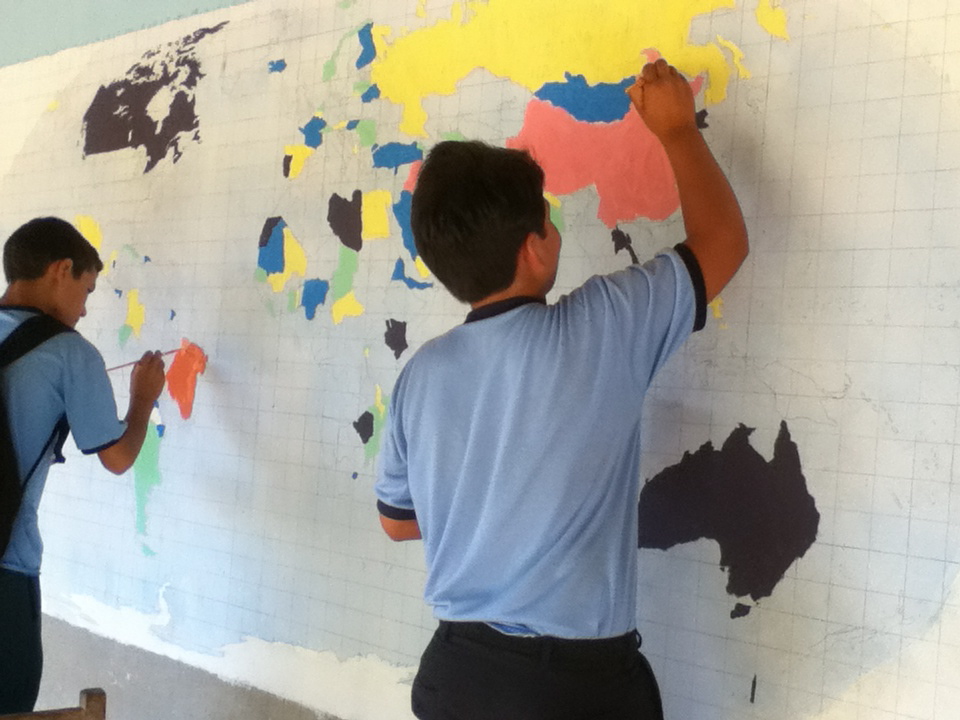 That’s what I got from the 6th graders. To be fair I don’t remember studying the world map extensively myself before Geography in 6th grade, but I did remember having a whole class period just on Geography several times a week throughout elementary and early middle school. However, I do distinctly remember learning about those topics in detail. The kids genuinely seemed afraid to do the project itself regardless of the fact that they likely had no idea what the world looks like. When your education and grades are based a lot on how neatly organized your work is copied from the board it is no wonder that when asked to do something that was intended for them to think creatively it caused them to struggle. It was like they didn’t even grasp the concept let alone do the activity in a manner that was correct. No matter how much I emphasized that it wasn’t a test, it was purely what you thought, and it was meant to be fun the students still stared up on my with looks of confusion that mirrored someone who is speaking a completely foreign language that they have never heard before.
  I decided that if the oldest group of kids in the school struggled that mightily with the project that I shouldn’t attempt to go much younger than them. As a benchmark I rode my bike home and sat down with Mathias, who is in 5th grade at that school, to see if he could do it. I figured that because he knew me better, and speaks good Spanish that he would have a bit more confidence, but like the other kids he immediately shied away from the activity saying he didn’t know. I demonstrated that even I didn’t know how to do it exactly right by drawing my own map to the best of my ability. From that I got him to draw a map of Paraguay, but even still he wouldn’t do it unless I did it first. The 5th graders don’t have class today because Iris has to go get materials for the garden project, so I will have to wait and see how that turns out on Monday.
  What I gathered from this whole experience was 2 things in particular. First, how difficult it was for the students to understand what I was asking them to do. I think that the standardization of the education system with huge emphasis on memorization and writing verbatim every word the teachers put on the board has a lot to do with it. The schools seems to lack a lot of creativity and free thinking in the curriculum that will prove to be challenging for me after having been educated my whole life in a liberal arts context. Second, the activity itself showed that these kids have no idea how big the world is outside of Paraguay relatively speaking of course. It goes back to the blog entry I wrote a few weeks ago about scale. There is Paraguay and the rest of the world in the minds of a lot of Paraguayans especially those that live outside of major cities. The problem being that these students have no idea what the rest of the world looks like, and I feel like this is a perfect opportunity for me to help them learn about it by doing a world map project that will hopefully give them context about where their country is in relation to the rest of the world. The pictures show the process from start to finish. I will add pictures of the competed map in the next entry.
No comments:
Post a Comment